
图片文件尺寸 : 4909 x 2839px
Joos van Winghe的《音乐制作》-Joos van Winghe
一家音乐制作--Joos van Winghe (荷兰, 1542-1603)
图片文件尺寸 : 4909 x 2839px
Joos van Winghe的《音乐制作》-Joos van Winghe
一家音乐制作--Joos van Winghe (荷兰, 1542-1603)

图片文件尺寸 : 4909 x 2839px
Joos van Winghe的《音乐制作》-Joos van Winghe
A Music Making Company--Joos van Winghe (荷兰, 1542-1603)

图片文件尺寸 : 3756 x 3004px
Joos van Winghe的《财富、欲望和愚蠢的寓言》-Joos van Winghe
Allegory of Wealth, Lust and Stupidity--Joos van Winghe (荷兰, 1542-1603)

图片文件尺寸 : 3022 x 2635px
《迪利拉的背叛和参孙被非利士人囚禁》(Joos van Winghe)-the Philistines by Joos van Winghe
Delilah’s Betrayal and Samson’s Imprisonment--Joos van Winghe (荷兰, 1542-1603)

图片文件尺寸 : 5053 x 5521px
After Joos van Winghe:
The Nativity
oil on panel, stamped with a clover leaf, the house mark of Michiel Claessens (on the reverse)
81.2 x 65cm (31 15/16 x 25 9/16in).
源自Joos van Winghe 基督降生记

图片文件尺寸 : 5074 x 4552px
LAS CASAS, BARTOLOME DE. :Narratio Regionum Indicarum Per Hispanos Quosdam Devastatarum Verissima.... Frankfurt: Theodor de Bry and Johann Saur, 1598.
4to (202 x 160 mm). Title printed within wide pictorial engraved border, 17 engraved half-page illustrations in text by the brothers de Bry after Josse van Winghe. [8], 141, [1] pp., lacking the final blank. Modern half brown morocco; front joint rubbed, some light staining and foxing, title border and one other engraving trimmed close at fore-edge.
Provenance: Royal Institution of Great Britain (library and discard stamps on front paste-down, gilt stamp on spine).
FIRST LATIN EDITION of Las Casas\'s classic work, which includes the celebrated series of plates depicting the atrocities committed by the Spanish settlers on the Indians. Alden 598.20; Church 320; Palau 46960; Sabin 11283.
房子,巴托洛姆·德。 《根据西班牙法定人数进行的印度地区叙事》Devastatarum Verissima……法兰克福:Theodor de Bry和Johann Saur,1598年。
图片文件尺寸 : 4455 x 4726px
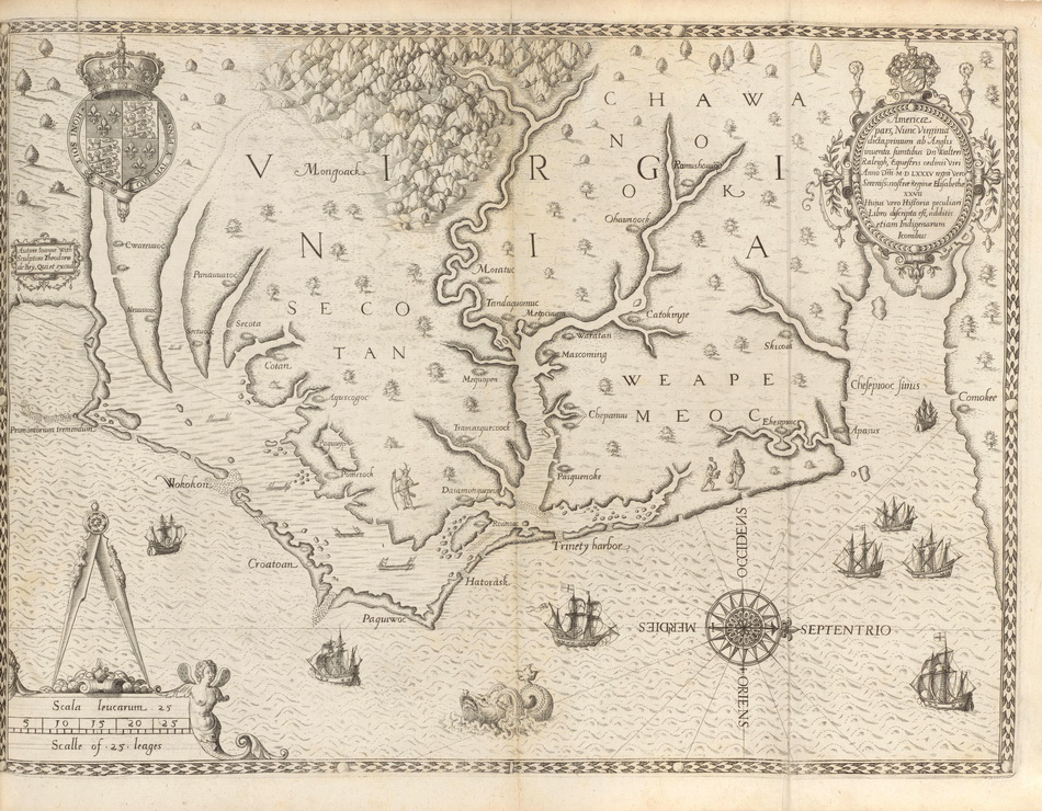
BRY, THEODOR DE. 1528-1598; AND THOMAS HARIOT.:Admiranda Narratio Fida Tamen, de Commodis et Incolarum Ritibus Virginiae. Frankfurt: Johann Wechel, 1590.
Folio (332 x 240 mm). Engraved title (first issue, see below), engraved arms on dedication leaf, double-page engraved map of Virginia in first state, engraved plate of Adam and Eve in first state with inscription \"Iodocus a winghe in Theodore de Bry fe.\" and 27 engraved plates after John White. Late 19th-century red morocco gilt by \"Bradstreet\'s for J. Comly MacCoy,\" gilt edges. Some light mostly marginal staining. Provenance: J.C. MacCoy (booklabel and binding).
FIRST EDITION, MOSTLY FIRST ISSUE (see below) OF THE FIRST VOLUME OF DE BRY\'S GREAT VOYAGES, BEING THOMAS HARIOT\'S DESCRIPTION OF VIRGINIA, and published during De Bry\'s lifetime. Thomas Hariot accompanied the 1585 expedition to Roanoke funded by Sir Walter Raleigh and acted as a translator. He had learned Carolina Algonquian from two Roanoke chiefs brought to England by Raleigh the year before. His account is a very encouraging one as the mysterious disappearance of Roanoke colony was not reported in Europe until John White, the expedition artist and mapmaker, returned in 1590.The 23 illustrations to the text, which are after John White\'s drawings, are by far the most important visual record of New World natives as first encountered by the English colonists. Also included is the highly important double-page map, the first map to identify Chesapeake Bay and \"the first printed map of this degree of detail and accuracy for any part of the present area of the United States\" (Cumming). It was dubbed by Burden \"one of the most significant cartographical milestones in colonial North American history ... the most accurate map drawn in the sixteenth century of any part of that continent. It became the prototype of the area until long after James Moxon\'s map in 1671... This is the first map to focus on Virginia (now largely North Carolina), and records the first English attempts at colonization in the New World. First issue engraved title as Church 140a, the plate not worn but without the printed \"cum gratia et privilege...\" at the bottom of the title panel. Map and most plates in first issue (plates 4, 7, 11, 12 second issue). D6 is a blank and genuine. Burden 76 (first state); Church 140; Cumming Southeast 12-13; European Americana 590/31; Sabin 8784.
布莱,西奥多·德。1528-1598年托马斯·哈里奥特。 弗吉尼亚州商业和国际贸易部。法兰克福:约翰·韦切尔,1590年。
图片文件尺寸 : 4909 x 2839px
Joos van Winghe的《音乐制作》-Joos van Winghe
一家音乐制作--Joos van Winghe (荷兰, 1542-1603)
图片文件尺寸 : 4909 x 2839px
Joos van Winghe的《音乐制作》-Joos van Winghe
A Music Making Company--Joos van Winghe (荷兰, 1542-1603)
图片文件尺寸 : 3756 x 3004px
Joos van Winghe的《财富、欲望和愚蠢的寓言》-Joos van Winghe
Allegory of Wealth, Lust and Stupidity--Joos van Winghe (荷兰, 1542-1603)
图片文件尺寸 : 3022 x 2635px
《迪利拉的背叛和参孙被非利士人囚禁》(Joos van Winghe)-the Philistines by Joos van Winghe
Delilah’s Betrayal and Samson’s Imprisonment--Joos van Winghe (荷兰, 1542-1603)
图片文件尺寸 : 5053 x 5521px
After Joos van Winghe:
The Nativity
oil on panel, stamped with a clover leaf, the house mark of Michiel Claessens (on the reverse)
81.2 x 65cm (31 15/16 x 25 9/16in).
源自Joos van Winghe 基督降生记
图片文件尺寸 : 5074 x 4552px
LAS CASAS, BARTOLOME DE. :Narratio Regionum Indicarum Per Hispanos Quosdam Devastatarum Verissima.... Frankfurt: Theodor de Bry and Johann Saur, 1598.
4to (202 x 160 mm). Title printed within wide pictorial engraved border, 17 engraved half-page illustrations in text by the brothers de Bry after Josse van Winghe. [8], 141, [1] pp., lacking the final blank. Modern half brown morocco; front joint rubbed, some light staining and foxing, title border and one other engraving trimmed close at fore-edge.
Provenance: Royal Institution of Great Britain (library and discard stamps on front paste-down, gilt stamp on spine).
FIRST LATIN EDITION of Las Casas\'s classic work, which includes the celebrated series of plates depicting the atrocities committed by the Spanish settlers on the Indians. Alden 598.20; Church 320; Palau 46960; Sabin 11283.
房子,巴托洛姆·德。 《根据西班牙法定人数进行的印度地区叙事》Devastatarum Verissima……法兰克福:Theodor de Bry和Johann Saur,1598年。
图片文件尺寸 : 4455 x 4726px
BRY, THEODOR DE. 1528-1598; AND THOMAS HARIOT.:Admiranda Narratio Fida Tamen, de Commodis et Incolarum Ritibus Virginiae. Frankfurt: Johann Wechel, 1590.
Folio (332 x 240 mm). Engraved title (first issue, see below), engraved arms on dedication leaf, double-page engraved map of Virginia in first state, engraved plate of Adam and Eve in first state with inscription \"Iodocus a winghe in Theodore de Bry fe.\" and 27 engraved plates after John White. Late 19th-century red morocco gilt by \"Bradstreet\'s for J. Comly MacCoy,\" gilt edges. Some light mostly marginal staining. Provenance: J.C. MacCoy (booklabel and binding).
FIRST EDITION, MOSTLY FIRST ISSUE (see below) OF THE FIRST VOLUME OF DE BRY\'S GREAT VOYAGES, BEING THOMAS HARIOT\'S DESCRIPTION OF VIRGINIA, and published during De Bry\'s lifetime. Thomas Hariot accompanied the 1585 expedition to Roanoke funded by Sir Walter Raleigh and acted as a translator. He had learned Carolina Algonquian from two Roanoke chiefs brought to England by Raleigh the year before. His account is a very encouraging one as the mysterious disappearance of Roanoke colony was not reported in Europe until John White, the expedition artist and mapmaker, returned in 1590.The 23 illustrations to the text, which are after John White\'s drawings, are by far the most important visual record of New World natives as first encountered by the English colonists. Also included is the highly important double-page map, the first map to identify Chesapeake Bay and \"the first printed map of this degree of detail and accuracy for any part of the present area of the United States\" (Cumming). It was dubbed by Burden \"one of the most significant cartographical milestones in colonial North American history ... the most accurate map drawn in the sixteenth century of any part of that continent. It became the prototype of the area until long after James Moxon\'s map in 1671... This is the first map to focus on Virginia (now largely North Carolina), and records the first English attempts at colonization in the New World. First issue engraved title as Church 140a, the plate not worn but without the printed \"cum gratia et privilege...\" at the bottom of the title panel. Map and most plates in first issue (plates 4, 7, 11, 12 second issue). D6 is a blank and genuine. Burden 76 (first state); Church 140; Cumming Southeast 12-13; European Americana 590/31; Sabin 8784.
布莱,西奥多·德。1528-1598年托马斯·哈里奥特。 弗吉尼亚州商业和国际贸易部。法兰克福:约翰·韦切尔,1590年。