
材质 :
图片文件尺寸 : 5222 x 3955 px
Atlantik-10 Bll. Seekarten des Atlantik/Ostsee/Pazifik/Mittelmeer., 1640.
大西洋-100亿。大西洋/波罗的海/太平洋/地中海海图,1640
材质 :
图片文件尺寸 : 5222 x 3955 px
Atlantik-10 Bll. Seekarten des Atlantik/Ostsee/Pazifik/Mittelmeer., 1640.
大西洋-100亿。大西洋/波罗的海/太平洋/地中海海图,1640
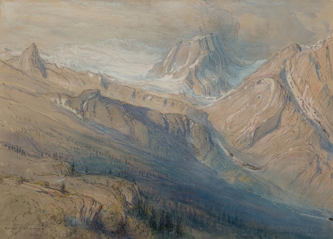
图片文件尺寸 : 2897 x 2083px
塞缪尔·科尔曼的《来自加拿大太平洋罗杰斯山口的隐士山脉》-Samuel Colman
The Hermit Range from Rogers Pass, Canadian Pacific--Samuel Colman (美国, 1832-1920)

图片文件尺寸 : 3936 x 5679px
F.T.S.:ORIENT PACIFIC LINE. AUSTRALIA and LONDON
lithographic poster in colour, printed by Grant Co., Ltd., London, cond. A-, backed on linen
31 x 36ins. (79 x 62cm.)
F、 T.秒。 东太平洋线。澳大利亚和伦敦

图片文件尺寸 : 9024 x 12164px
古斯塔夫·威廉·克罗尔曼(Gustav Wilhelm Krollmann)的圣海伦山北太平洋北海岸有限-Gustav Wilhelm Krollmann
Mt. St. Helens Northern Pacific North Coast Limited--Gustav Wilhelm Krollmann (奥地利, 1888-1962)

图片文件尺寸 : 4409 x 5703px
Gustave Baumann:Pacific Shore Line (Chamberlain 173), 1948
Woodcut in colors on Zanders laid paper with the \'Hand-in-Heart\' watermark, signed in pencil, titled, dated and numbered 4/125, with full margins, framed.
12 7/8 x 12 3/4in (32.7 x 32.4cm)
sheet 17 x 14 3/8in (43.2 x 36.5cm)
古斯塔夫·鲍曼 太平洋海岸线

图片文件尺寸 : 4866 x 4534px
Bernard Bedwell Portal:A village scene from a South Pacific island
signed and dated \'B.B.Portal 1896\' (lower right)
oil on canvas
41 x 61.6cm (16 1/8 x 24 1/4in).
伯纳德·贝德韦尔门户 南太平洋岛屿上的村庄景象

图片文件尺寸 : 5245 x 5426px
S. STOTT:to NEW YORK SOUTH AMERICA. ROYAL MAIL STEAM PACKET Co. PACIFIC STEAM NAVIGATION Co
lithographic poster in colours, 1922, cond. A, backed on linen
35 x 24.5ins. (89 x 62cm.)
S、 斯托特牌手表 前往纽约和南美。皇家邮件蒸汽包太平洋蒸汽导航
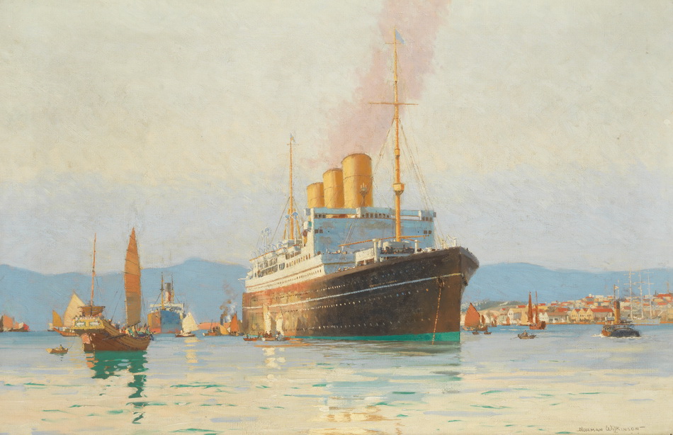
图片文件尺寸 : 5238 x 5064px
Norman Wilkinson:The Canadian Pacific liner Empress of Canada lying in Hong Kong harbour
signed \'NORMAN WILKINSON-\' (lower right)
oil on canvas
66.3 x 100cm (26 1/8 x 39 3/8in).
诺曼·威尔金森 加拿大太平洋班轮加拿大皇后号停靠香港港
![Insulae Americanae in Oceano Septentrionali, cum Terris adjacentibus. Amsterdam: [1635 or later].](http://www.minghuafuzhi.com/2022/12/02143946193.jpg)
图片文件尺寸 : 4619 x 4351px
BLAEU, WILLEM. 1571-1638.:Insulae Americanae in Oceano Septentrionali, cum Terris adjacentibus. Amsterdam: [1635 or later].
Engraved map of the Caribbean, hand-colored in outline with elaborately decorated cartouches, 390 x 540 mm. Matted and framed.
Burden Mapping of North America 242.
蓝色,威尔。1571-1638. 西太平洋上的美国岛屿及其邻近国家。阿姆斯特丹:[1635年或更晚]。
材质 :
图片文件尺寸 : 5222 x 3955 px
Atlantik-10 Bll. Seekarten des Atlantik/Ostsee/Pazifik/Mittelmeer., 1640.
大西洋-100亿。大西洋/波罗的海/太平洋/地中海海图,1640
图片文件尺寸 : 2897 x 2083px
塞缪尔·科尔曼的《来自加拿大太平洋罗杰斯山口的隐士山脉》-Samuel Colman
The Hermit Range from Rogers Pass, Canadian Pacific--Samuel Colman (美国, 1832-1920)
图片文件尺寸 : 3936 x 5679px
F.T.S.:ORIENT PACIFIC LINE. AUSTRALIA and LONDON
lithographic poster in colour, printed by Grant Co., Ltd., London, cond. A-, backed on linen
31 x 36ins. (79 x 62cm.)
F、 T.秒。 东太平洋线。澳大利亚和伦敦
图片文件尺寸 : 9024 x 12164px
古斯塔夫·威廉·克罗尔曼(Gustav Wilhelm Krollmann)的圣海伦山北太平洋北海岸有限-Gustav Wilhelm Krollmann
Mt. St. Helens Northern Pacific North Coast Limited--Gustav Wilhelm Krollmann (奥地利, 1888-1962)
图片文件尺寸 : 4409 x 5703px
Gustave Baumann:Pacific Shore Line (Chamberlain 173), 1948
Woodcut in colors on Zanders laid paper with the \'Hand-in-Heart\' watermark, signed in pencil, titled, dated and numbered 4/125, with full margins, framed.
12 7/8 x 12 3/4in (32.7 x 32.4cm)
sheet 17 x 14 3/8in (43.2 x 36.5cm)
古斯塔夫·鲍曼 太平洋海岸线
图片文件尺寸 : 4866 x 4534px
Bernard Bedwell Portal:A village scene from a South Pacific island
signed and dated \'B.B.Portal 1896\' (lower right)
oil on canvas
41 x 61.6cm (16 1/8 x 24 1/4in).
伯纳德·贝德韦尔门户 南太平洋岛屿上的村庄景象
图片文件尺寸 : 5245 x 5426px
S. STOTT:to NEW YORK SOUTH AMERICA. ROYAL MAIL STEAM PACKET Co. PACIFIC STEAM NAVIGATION Co
lithographic poster in colours, 1922, cond. A, backed on linen
35 x 24.5ins. (89 x 62cm.)
S、 斯托特牌手表 前往纽约和南美。皇家邮件蒸汽包太平洋蒸汽导航
图片文件尺寸 : 5238 x 5064px
Norman Wilkinson:The Canadian Pacific liner Empress of Canada lying in Hong Kong harbour
signed \'NORMAN WILKINSON-\' (lower right)
oil on canvas
66.3 x 100cm (26 1/8 x 39 3/8in).
诺曼·威尔金森 加拿大太平洋班轮加拿大皇后号停靠香港港
图片文件尺寸 : 4619 x 4351px
BLAEU, WILLEM. 1571-1638.:Insulae Americanae in Oceano Septentrionali, cum Terris adjacentibus. Amsterdam: [1635 or later].
Engraved map of the Caribbean, hand-colored in outline with elaborately decorated cartouches, 390 x 540 mm. Matted and framed.
Burden Mapping of North America 242.
蓝色,威尔。1571-1638. 西太平洋上的美国岛屿及其邻近国家。阿姆斯特丹:[1635年或更晚]。