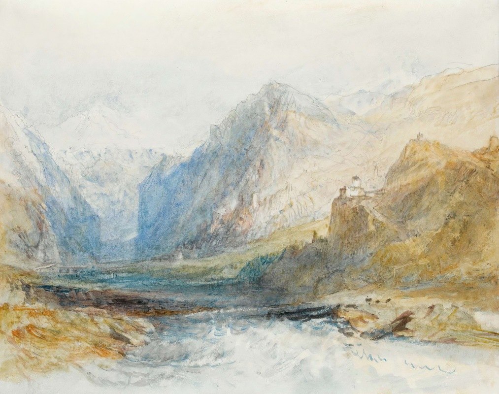
图片文件尺寸 : 4700 x 3713px
约瑟夫·马洛德·威廉·透纳(Joseph Mallord William Turner)的《多姆勒施格山谷,向北眺望罗滕布伦峡谷》-Joseph Mallord William Turner
Domleschg山谷,向北眺望Rothenbrünnen峡谷--Joseph Mallord William Turner (英国, 1775-1851)
图片文件尺寸 : 4700 x 3713px
约瑟夫·马洛德·威廉·透纳(Joseph Mallord William Turner)的《多姆勒施格山谷,向北眺望罗滕布伦峡谷》-Joseph Mallord William Turner
Domleschg山谷,向北眺望Rothenbrünnen峡谷--Joseph Mallord William Turner (英国, 1775-1851)
 图片文件像素:4600 x 3500 px
詹姆斯·罗森奎斯特-
-
(Grand Forks, North Dakota 1933-2017 New York City)
"A Free for all", 1976, Lithographie in Farbe mit collagierter Kordel auf Velin, signiert und datiert Rosenquist 1976 sowie betitelt, Nr. Nr. 21 von 25 nummerierten Exemplaren Hors Commerce, blattgroßer Druck ca. 66 x 51,5 cm, erschienen innerhalb des Portfolio 'Look out beyond and see: An 美国 portrait 1776-1976', gedruckt bei Derriere L'Etoile Studios und herausgegeben von Transworld Art/New York mit dem Trockenstempel, gerahmt beschrieben, (RAC)
![America. Amsterdam: [1628].](http://www.minghuafuzhi.com/2022/12/02140048903.jpg)
图片文件尺寸 : 5183 x 4525px
:America. Amsterdam: [1628].
Hand-colored engraved map, 384 x 507 mm. French text on verso, seas decorated with ships and sea creatures and large inset scene of Brazilian natives. Vertical creases alongside centerfold. Framed.
A fine decorative map from the Golden Age of Dutch Cartography. Hondius used \"various scenes taken from the earlier volumes of de Bry\'s Grand Voyages to adorn the whole. Particularly notable is the native Brazilian scene illustrating the method used to make a local beverage.\" Burden Mapping of North America 150.
无 题 美国阿姆斯特丹:[1628]。
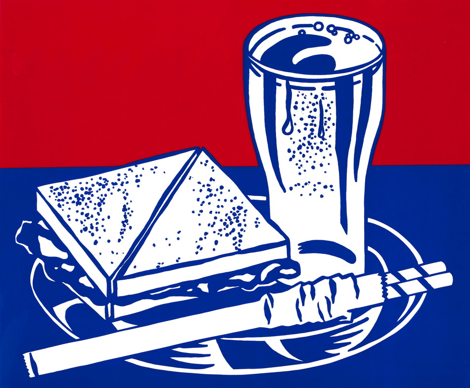
图片文件尺寸 : 5203 x 5797px
Roy Lichtenstein:Sandwich and Soda, from the X + X (Ten Works by Ten Painters) (Corlett 35), 1964
Screenprint in colors on clear plastic, unsigned as issued, from the edition of 500, published by the Wadsworth Atheneum, Hartford, Connecticut, printed by Sirocco Screenprints, North Haven, Connecticut, with full margins, framed.
19 x 23in (48.3 x 58.4cm)
sheet 20 x 24in (50.8 x 61cm)
罗伊·利希滕斯坦 三明治和苏打,来自X+X
![A collection of approximately 90 Views of cities and landscapes of Australia and New Zealand, and 30 views of the United States, [1870/80s]](http://www.minghuafuzhi.com/2022/12/03090652227.jpg)
图片文件尺寸 : 4881 x 5150px
AUSTRALIA, NEW ZEALAND AND NORTH AMERICA:
澳大利亚、新西兰和北美 收集了大约90幅澳大利亚和新西兰的城市和景观视图,以及30幅美国视图,[1970/80]
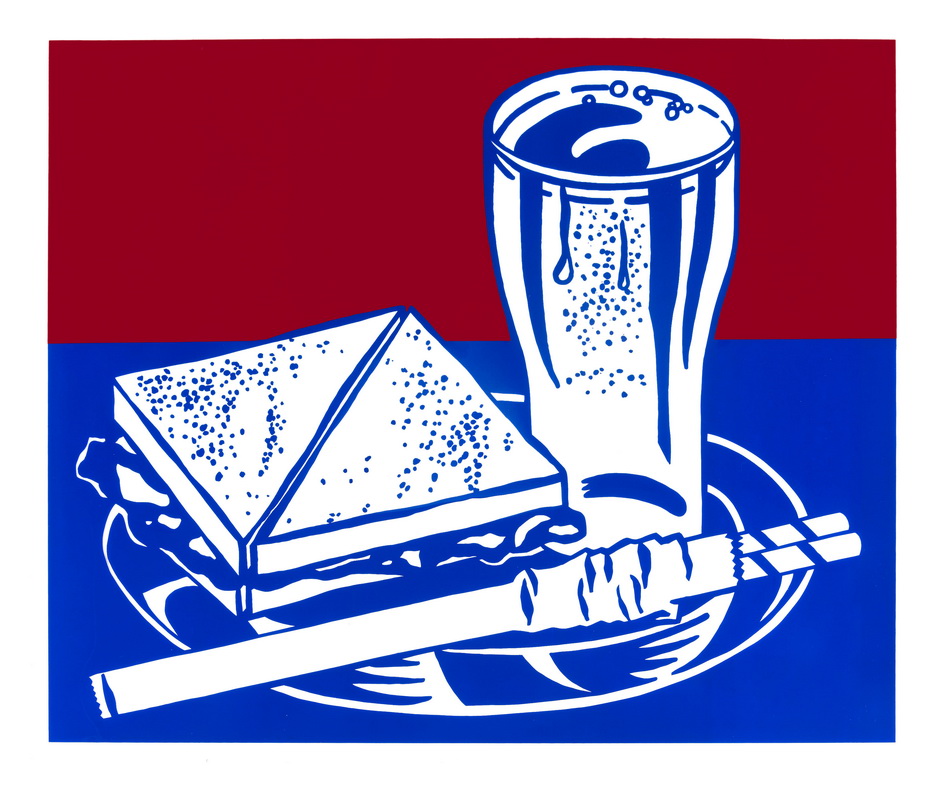
图片文件尺寸 : 4674 x 5669px
Roy Lichtenstein:
Sandwich and Soda, from the X + X (Ten Works by Ten Painters) portfolio (Corlett 35), 1964
Screenprint in colors on clear plastic, unsigned as issued, from the edition of 500, published by the Wadsworth Atheneum, Hartford, Connecticut, printed by Sirocco Screenprints, North Haven, Connecticut, with full margins.
19 x 23in (48.3 x 58.4cm)
sheet 20 x 24in (50.8 x 61cm)
罗伊·利希滕斯坦 三明治和苏打水,来自X+X组合
![Insulae Americanae in Oceano Septentrionali, cum Terris adjacentibus. Amsterdam: [1635 or later].](http://www.minghuafuzhi.com/2022/12/02143946193.jpg)
图片文件尺寸 : 4619 x 4351px
BLAEU, WILLEM. 1571-1638.:Insulae Americanae in Oceano Septentrionali, cum Terris adjacentibus. Amsterdam: [1635 or later].
Engraved map of the Caribbean, hand-colored in outline with elaborately decorated cartouches, 390 x 540 mm. Matted and framed.
Burden Mapping of North America 242.
蓝色,威尔。1571-1638. 西太平洋上的美国岛屿及其邻近国家。阿姆斯特丹:[1635年或更晚]。

图片文件尺寸 : 4096 x 3276px
塞缪尔·帕尔默的《佛兰德和北威尔士卡佩尔·库里格和贝德格勒特之间的Llyn-y镇的一部分》-Samuel Palmer
北威尔士Capel Curig和Beddegelert之间的花卉和部分花卉--Samuel Palmer (英国, 1805-1881)
图片文件尺寸 : 4455 x 4726px
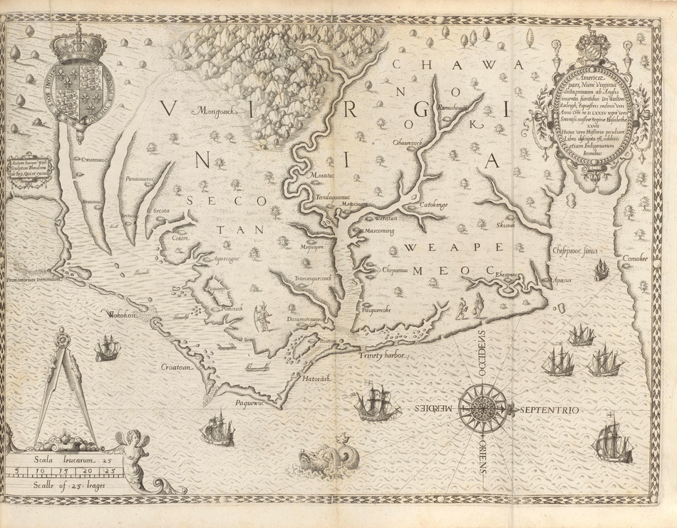
BRY, THEODOR DE. 1528-1598; AND THOMAS HARIOT.:Admiranda Narratio Fida Tamen, de Commodis et Incolarum Ritibus Virginiae. Frankfurt: Johann Wechel, 1590.
Folio (332 x 240 mm). Engraved title (first issue, see below), engraved arms on dedication leaf, double-page engraved map of Virginia in first state, engraved plate of Adam and Eve in first state with inscription \"Iodocus a winghe in Theodore de Bry fe.\" and 27 engraved plates after John White. Late 19th-century red morocco gilt by \"Bradstreet\'s for J. Comly MacCoy,\" gilt edges. Some light mostly marginal staining. Provenance: J.C. MacCoy (booklabel and binding).
FIRST EDITION, MOSTLY FIRST ISSUE (see below) OF THE FIRST VOLUME OF DE BRY\'S GREAT VOYAGES, BEING THOMAS HARIOT\'S DESCRIPTION OF VIRGINIA, and published during De Bry\'s lifetime. Thomas Hariot accompanied the 1585 expedition to Roanoke funded by Sir Walter Raleigh and acted as a translator. He had learned Carolina Algonquian from two Roanoke chiefs brought to England by Raleigh the year before. His account is a very encouraging one as the mysterious disappearance of Roanoke colony was not reported in Europe until John White, the expedition artist and mapmaker, returned in 1590.The 23 illustrations to the text, which are after John White\'s drawings, are by far the most important visual record of New World natives as first encountered by the English colonists. Also included is the highly important double-page map, the first map to identify Chesapeake Bay and \"the first printed map of this degree of detail and accuracy for any part of the present area of the United States\" (Cumming). It was dubbed by Burden \"one of the most significant cartographical milestones in colonial North American history ... the most accurate map drawn in the sixteenth century of any part of that continent. It became the prototype of the area until long after James Moxon\'s map in 1671... This is the first map to focus on Virginia (now largely North Carolina), and records the first English attempts at colonization in the New World. First issue engraved title as Church 140a, the plate not worn but without the printed \"cum gratia et privilege...\" at the bottom of the title panel. Map and most plates in first issue (plates 4, 7, 11, 12 second issue). D6 is a blank and genuine. Burden 76 (first state); Church 140; Cumming Southeast 12-13; European Americana 590/31; Sabin 8784.
布莱,西奥多·德。1528-1598年托马斯·哈里奥特。 弗吉尼亚州商业和国际贸易部。法兰克福:约翰·韦切尔,1590年。
![Nova Belgica et Anglia nova. Amsterdam: [1642 or later].](http://www.minghuafuzhi.com/2022/12/02141254198.jpg)
图片文件尺寸 : 4438 x 5159px
:Nova Belgica et Anglia nova. Amsterdam: [1642 or later].
Hand-colored double-page engraved map, 388 x 507 mm, Dutch text on verso, decorative cartouche flanked by a native person on each side and surmounted by the Dutch Republic crest, scale bar flanked by mer-children, decorated with three ships, three canoes paddled by natives, a Mohican village, various wildlife including deer, foxes, bears, egrets, rabbits, cranes, turkeys and for the first time on a map beavers, polecats and otters. Framed. Centerfold reinforced on verso, small area of skinning in the Atlantic, but an attractive example.
Blaeu\'s seminal map was the first full printed representation of the manuscript map of Adriaen Block. It is one of the earliest to name Nieu Amsterdam and the earliest to depict insular Manhattan. Burden North America 241.
无 题 新比利时和英格兰阿姆斯特丹:[1642年或更晚]。
图片文件尺寸 : 4700 x 3713px
约瑟夫·马洛德·威廉·透纳(Joseph Mallord William Turner)的《多姆勒施格山谷,向北眺望罗滕布伦峡谷》-Joseph Mallord William Turner
Domleschg山谷,向北眺望Rothenbrünnen峡谷--Joseph Mallord William Turner (英国, 1775-1851)
图片文件像素:4600 x 3500 px
詹姆斯·罗森奎斯特-
-
(Grand Forks, North Dakota 1933-2017 New York City)
"A Free for all", 1976, Lithographie in Farbe mit collagierter Kordel auf Velin, signiert und datiert Rosenquist 1976 sowie betitelt, Nr. Nr. 21 von 25 nummerierten Exemplaren Hors Commerce, blattgroßer Druck ca. 66 x 51,5 cm, erschienen innerhalb des Portfolio 'Look out beyond and see: An 美国 portrait 1776-1976', gedruckt bei Derriere L'Etoile Studios und herausgegeben von Transworld Art/New York mit dem Trockenstempel, gerahmt beschrieben, (RAC)
图片文件尺寸 : 5183 x 4525px
:America. Amsterdam: [1628].
Hand-colored engraved map, 384 x 507 mm. French text on verso, seas decorated with ships and sea creatures and large inset scene of Brazilian natives. Vertical creases alongside centerfold. Framed.
A fine decorative map from the Golden Age of Dutch Cartography. Hondius used \"various scenes taken from the earlier volumes of de Bry\'s Grand Voyages to adorn the whole. Particularly notable is the native Brazilian scene illustrating the method used to make a local beverage.\" Burden Mapping of North America 150.
无 题 美国阿姆斯特丹:[1628]。
图片文件尺寸 : 5203 x 5797px
Roy Lichtenstein:Sandwich and Soda, from the X + X (Ten Works by Ten Painters) (Corlett 35), 1964
Screenprint in colors on clear plastic, unsigned as issued, from the edition of 500, published by the Wadsworth Atheneum, Hartford, Connecticut, printed by Sirocco Screenprints, North Haven, Connecticut, with full margins, framed.
19 x 23in (48.3 x 58.4cm)
sheet 20 x 24in (50.8 x 61cm)
罗伊·利希滕斯坦 三明治和苏打,来自X+X
图片文件尺寸 : 4881 x 5150px
AUSTRALIA, NEW ZEALAND AND NORTH AMERICA:
澳大利亚、新西兰和北美 收集了大约90幅澳大利亚和新西兰的城市和景观视图,以及30幅美国视图,[1970/80]
图片文件尺寸 : 4674 x 5669px
Roy Lichtenstein:
Sandwich and Soda, from the X + X (Ten Works by Ten Painters) portfolio (Corlett 35), 1964
Screenprint in colors on clear plastic, unsigned as issued, from the edition of 500, published by the Wadsworth Atheneum, Hartford, Connecticut, printed by Sirocco Screenprints, North Haven, Connecticut, with full margins.
19 x 23in (48.3 x 58.4cm)
sheet 20 x 24in (50.8 x 61cm)
罗伊·利希滕斯坦 三明治和苏打水,来自X+X组合
图片文件尺寸 : 4619 x 4351px
BLAEU, WILLEM. 1571-1638.:Insulae Americanae in Oceano Septentrionali, cum Terris adjacentibus. Amsterdam: [1635 or later].
Engraved map of the Caribbean, hand-colored in outline with elaborately decorated cartouches, 390 x 540 mm. Matted and framed.
Burden Mapping of North America 242.
蓝色,威尔。1571-1638. 西太平洋上的美国岛屿及其邻近国家。阿姆斯特丹:[1635年或更晚]。
图片文件尺寸 : 4096 x 3276px
塞缪尔·帕尔默的《佛兰德和北威尔士卡佩尔·库里格和贝德格勒特之间的Llyn-y镇的一部分》-Samuel Palmer
北威尔士Capel Curig和Beddegelert之间的花卉和部分花卉--Samuel Palmer (英国, 1805-1881)
图片文件尺寸 : 4455 x 4726px
BRY, THEODOR DE. 1528-1598; AND THOMAS HARIOT.:Admiranda Narratio Fida Tamen, de Commodis et Incolarum Ritibus Virginiae. Frankfurt: Johann Wechel, 1590.
Folio (332 x 240 mm). Engraved title (first issue, see below), engraved arms on dedication leaf, double-page engraved map of Virginia in first state, engraved plate of Adam and Eve in first state with inscription \"Iodocus a winghe in Theodore de Bry fe.\" and 27 engraved plates after John White. Late 19th-century red morocco gilt by \"Bradstreet\'s for J. Comly MacCoy,\" gilt edges. Some light mostly marginal staining. Provenance: J.C. MacCoy (booklabel and binding).
FIRST EDITION, MOSTLY FIRST ISSUE (see below) OF THE FIRST VOLUME OF DE BRY\'S GREAT VOYAGES, BEING THOMAS HARIOT\'S DESCRIPTION OF VIRGINIA, and published during De Bry\'s lifetime. Thomas Hariot accompanied the 1585 expedition to Roanoke funded by Sir Walter Raleigh and acted as a translator. He had learned Carolina Algonquian from two Roanoke chiefs brought to England by Raleigh the year before. His account is a very encouraging one as the mysterious disappearance of Roanoke colony was not reported in Europe until John White, the expedition artist and mapmaker, returned in 1590.The 23 illustrations to the text, which are after John White\'s drawings, are by far the most important visual record of New World natives as first encountered by the English colonists. Also included is the highly important double-page map, the first map to identify Chesapeake Bay and \"the first printed map of this degree of detail and accuracy for any part of the present area of the United States\" (Cumming). It was dubbed by Burden \"one of the most significant cartographical milestones in colonial North American history ... the most accurate map drawn in the sixteenth century of any part of that continent. It became the prototype of the area until long after James Moxon\'s map in 1671... This is the first map to focus on Virginia (now largely North Carolina), and records the first English attempts at colonization in the New World. First issue engraved title as Church 140a, the plate not worn but without the printed \"cum gratia et privilege...\" at the bottom of the title panel. Map and most plates in first issue (plates 4, 7, 11, 12 second issue). D6 is a blank and genuine. Burden 76 (first state); Church 140; Cumming Southeast 12-13; European Americana 590/31; Sabin 8784.
布莱,西奥多·德。1528-1598年托马斯·哈里奥特。 弗吉尼亚州商业和国际贸易部。法兰克福:约翰·韦切尔,1590年。
图片文件尺寸 : 4438 x 5159px
:Nova Belgica et Anglia nova. Amsterdam: [1642 or later].
Hand-colored double-page engraved map, 388 x 507 mm, Dutch text on verso, decorative cartouche flanked by a native person on each side and surmounted by the Dutch Republic crest, scale bar flanked by mer-children, decorated with three ships, three canoes paddled by natives, a Mohican village, various wildlife including deer, foxes, bears, egrets, rabbits, cranes, turkeys and for the first time on a map beavers, polecats and otters. Framed. Centerfold reinforced on verso, small area of skinning in the Atlantic, but an attractive example.
Blaeu\'s seminal map was the first full printed representation of the manuscript map of Adriaen Block. It is one of the earliest to name Nieu Amsterdam and the earliest to depict insular Manhattan. Burden North America 241.
无 题 新比利时和英格兰阿姆斯特丹:[1642年或更晚]。